Lead Institution
CCARBON – Center for Carbon Research in Tropical Agriculture (University of São Paulo)
Supervisor
Prof. Dr. Matheus Pinheiro Ferreira (ESALQ/USP) e Prof. Dr. Paulo Guilherme Molin (UFSCAR)
Host Institution
ESALQ/USP, Piracicaba, São Paulo, Brazil
Fellowship
Postdoctoral fellowship funded by FEALQ (equivalent to FAPESP standard).
Stipend: R$ 12.000,00 per month
Duration
36 months (full-time dedication/40 hours per week)
Expected Start Date
Immediate
Project Title
Mangrove Assisted Restoration for Ecosystem Services (MARES)
Abstract
The MARES project investigates the potential of bioengineering structures (ROOT™) to restore mangrove forests, focusing on carbon sequestration and storage as well as the recovery of degraded ecosystem services. The study is centered in Cananéia (São Paulo coast, Brazil) and involves interdisciplinary approaches to quantify total ecosystem carbon stocks (TECS)—including above- and belowground biomass and soil organic carbon—in mangroves under different restoration strategies.
Project Description and Objectives
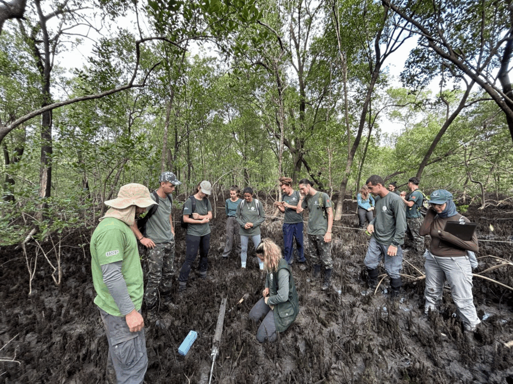
The postdoctoral fellow will map the degradation stage and conservation status of mangrove ecosystems across the State of São Paulo using remote sensing, with emphasis on airborne LiDAR point clouds and high-resolution orthophotos, complemented by other sensors where available (e.g., multispectral/hyperspectral). The researcher will design, implement, and evaluate state-of-the-art machine and deep learning methods for multimodal data fusion to generate robust, wall-to-wall products that quantify mangrove condition and support conservation and restoration actions.
Core responsibilities
Reference database development. Build a vetted, georeferenced reference database of mangrove areas across degradation stages (e.g., intact, lightly degraded, severely degraded). Integrate: (i) ALS LiDAR (DTM/DSM, CHM, structural metrics), (ii) expert photo-interpretation of orthophotos, and (iii) field campaigns with on-site validation to refine class definitions.
Data preparation & integration. Assemble a harmonized geospatial stack: LiDAR preprocessing (denoising, ground/non-ground classification, normalization, CHM/height/structural metrics), orthophoto processing, ingestion of ancillary imagery (multispectral/hyperspectral; SAR if available), precise co-registration, tiling, and radiometric/illumination normalization.
Labeling strategy & field support. Coordinate photo-interpretation and targeted field visits to construct high-quality labeled datasets; maintain labeling taxonomy and guidelines.
Modeling & data fusion. Once the reference database is complete, train and benchmark modern machine learning and deep learning approaches (e.g., 2D/3D CNNs, transformers, point-cloud networks) using early/intermediate/late fusion and attention mechanisms to classify conservation vs. degradation stages; explore complementary regression targets (e.g., degradation indices/structural metrics).
Validation & reporting. Conduct accuracy assessment with independent ground truth and spatially aware splits; report confusion matrices, IoU/F1, calibration/reliability, and produce uncertainty/suitability maps. Document methods, parameters, limitations, and data lineage.
Deliverables
Statewide mangrove conservation-status map for São Paulo (GeoTIFF/GeoPackage) with uncertainty layers.
Curated reference database with complete metadata.
Reproducible code repository (training/inference/validation).
Technical report and at least two manuscript submissions; contributions to partner training and outreach.
Candidate Requirements
Mandatory
– PhD completed in Remote Sensing, Forest Resources, Environmental Sciences, Geography, Computer Science, or related fields.
– Willingness to reside in Piracicaba, São Paulo (Brazil).
– Proficiency in English for reading, writing, and presenting scientific results.
– Valid driver’s license.
– Proven experience in scientific research, with publications in international peer-reviewed journals and technical-scientific reports.
– Ability to conduct fieldwork in coastal and remote environments.
– Experience in machine and deep learning for image classification.
– Availability for national and international travel for sampling campaigns, meetings, and training activities.
Desired (a plus)
– Previous experience with coastal ecosystems, especially mangroves.
– Proficiency in programming languages (Python and/or R)
– Knowledge of GIS and geoprocessing tools (QGIS, ArcGIS, or similar).
– Experience in collaborative and multidisciplinary research projects.
– Experience engaging with public institutions and/or local communities.
Application deadline
From September 25th to October 8th, 2025.
How to Apply
Applications must be submitted through the link of CCARBON open opportunities:
https://forms.gle/8iXKrs1VSHEiibGB8
Additional Information
For any questions, please contact us at: mpferreira@usp.br